The Joint Long Range Proving Ground, 1949
Why the Department of Defense picked the cape: overwater range, scrubland buffer, latitude that helped the math, and a Navy base already on the property.
The Department of Defense established the Joint Long Range Proving Ground at Cape Canaveral on May 11, 1949, after a six-month search for an East Coast missile test range. The choice was not obvious or universal. The competing site was El Centro, California. The cape won on four specific grounds. First, it offered an overwater range east into the Atlantic with no civilian population for thousands of miles. Second, it was at 28.5 degrees north latitude, which boosts orbital launches with extra rotational velocity. Third, the land was already partly military: NAS Banana River and its postwar Air Force successor occupied the south end of the cape. Fourth, the Florida hinterland was sparse, with the cape itself populated by perhaps 100 people who could be bought out or relocated.
The Pendray report and the alternative sites
The Defense Department study that led to the cape pick was led by Major General Bernard Schriever’s predecessor at Air Materiel Command in late 1948. The shortlist included six sites: Cape Canaveral, the Banana River base specifically; El Centro and Edwards in California; Eglin Air Force Base in the Florida Panhandle; the New Mexico White Sands range; an undeveloped site in Texas; and Cape Cod in Massachusetts.
El Centro lost on range. The Pacific test corridor required negotiating with Mexico to fly over Baja California. The White Sands range was already in active use for the V-2 and Aerobee tests but offered only 100 miles of overland range before the rocket impact zones started threatening downstream civilian populations in El Paso. Eglin was rejected because the Gulf of Mexico range pointed at Mexico and Cuba and was politically untenable. Cape Cod failed on weather: too many no-fly days per year. Texas was undeveloped.
Cape Canaveral won by elimination as much as on merit. The eastern Atlantic range gave 5,000 miles of clear water from the cape to Ascension Island, with no inhabited landmass between. The Bahamas were British territory and Britain was a willing ally on the test program. The latitude was a bonus, not a deciding factor: 28.5 degrees north adds about 410 meters per second of velocity to an eastward launch, compared to about 280 meters per second at El Centro’s 32.8 degrees north. That margin matters at the edge of what early rockets could do.
What was already on site
The DOD didn’t have to buy out a virgin landscape. The cape’s south end held a former Navy base that was already in Air Force hands. The Air Force took possession of NAS Banana River on September 1, 1948, and renamed it Patrick Air Force Base in 1950. The base had a 6,000-foot runway, hangar space, barracks, an officers’ club, a port channel into the Banana River, and a road network. Patrick became the operational support base for the JLRPG. The launch sites went north onto the cape itself.
The cape’s north end was federal land in part, scrub in part, and private holdings in part. The Wilson family owned about 1,300 acres of orange groves. A few dozen smaller properties held 50 to 200 acres each, mostly fishing camps and pioneer homesteads. The cape lighthouse stood on what was already government property. A small fishing village of 50 to 100 year-round residents sat at the south end of the cape near what’s now Port Canaveral.
The Air Force began acquiring private parcels through condemnation proceedings in late 1949. Most owners settled. A few sued. The condemnation values averaged about $200 per acre, which was below market in 1949 dollars and a sore point for the displaced families. The federal acquisitions were essentially complete by 1953.
What the range was for
The JLRPG was a DoD facility, not yet a NASA or even an Air Force facility specifically. It was joint by design, intended to serve all three armed services: Air Force ballistic missiles, Army theater missiles, Navy fleet ballistic missiles, plus DOD research projects. The first launches were small and not particularly successful.
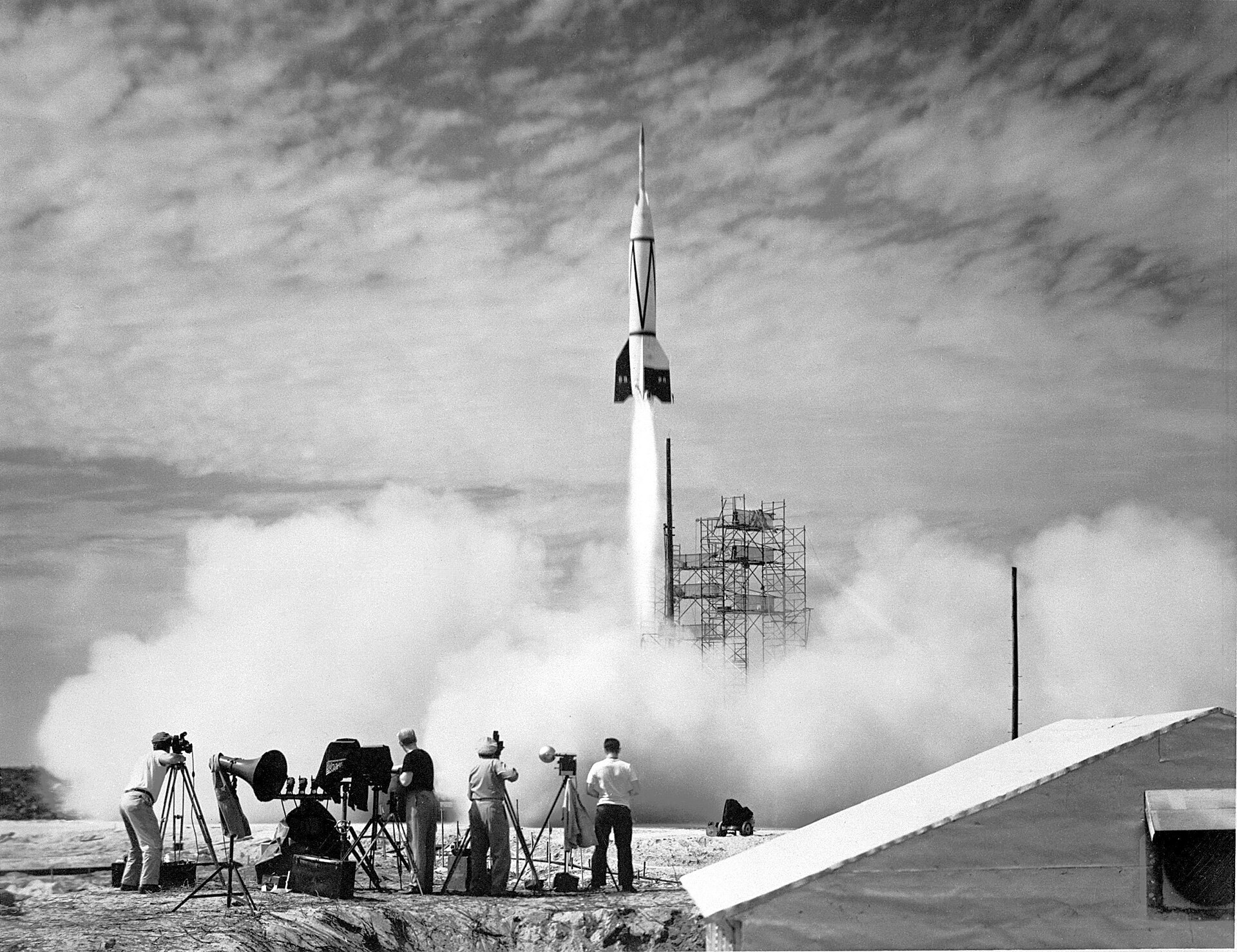
The first test launch from the cape was Bumper 8 on July 24, 1950, a V-2 first-stage with a WAC Corporal second stage. It reached about 30 miles altitude. The cape had been delivered.
Renaming
The JLRPG was renamed several times in the 1950s. In 1951, it became the Air Force Missile Test Center under USAF Air Research and Development Command. By 1958, it was the Atlantic Missile Range. By 1964, after NASA had stood up the Launch Operations Center on Merritt Island, the Air Force facility was the Cape Kennedy Air Force Station. By 1973, when Florida reversed the LBJ-era renaming, it was Cape Canaveral Air Force Station. In 2020 it became Cape Canaveral Space Force Station.
The institutional alphabet soup hides a simple continuity. From 1949 through today, the same patch of cape scrub has been the eastern American rocket range. NASA’s Kennedy Space Center, the civilian half, sits north of the original range on Merritt Island. The Air Force / Space Force half is the cape proper.
The Navy-to-Air-Force transfer date and the institutional sequence
The institutional handoff that made the JLRPG possible happened in two steps in two different years. The Navy transferred Naval Air Station Banana River to the Air Force on June 1, 1948, fifteen months after the Air Force was created as a separate service. The transfer was administered through the General Services Administration, with the Navy designating the base as surplus property the previous year.
The Air Force renamed the property as the Joint Long Range Proving Ground Base on June 10, 1949, four weeks after the Department of Defense formally established the JLRPG itself on May 11, 1949. On May 17, 1950, it became the Long Range Proving Ground Base. Three months later, in August 1950, it was renamed Patrick Air Force Base. The Air Force Missile Test Center was established at the same site in 1951 to administer the range.
That four-rename sequence in 30 months reflects how fast the institutional structure was being improvised. The cape was a working test range before its parent organization had a stable name.
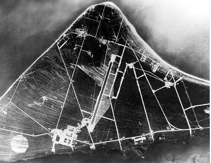
The 1950s cape: from Bumper 8 to the Cape Canaveral Missile Test Annex
The 1950s saw the cape transition from an ad-hoc range running one or two flights a month to a working production test facility. By 1955, the year of the Florida Memory aerial reproduced above, the cape had Launch Complexes 1, 2, 3, 4, 5, 6, 17, 18, and the early stages of LC-26 under construction. The launch pace had climbed to roughly one per week. The work was almost entirely Air Force ballistic missile testing: Matador, Snark, Bomarc, Thor, Jupiter, and the early Atlas.
The Air Force renamed the launch portion of the range as the Cape Canaveral Missile Test Annex from 1955 to 1964. This name distinguished the cape launch facility from the Patrick Air Force Base support installation eight miles south. The annex name held until the 1963 Cape Kennedy renaming. The institutional structure that handled launches separately from the support base is the same one operating in 2026, except the Cape Canaveral Space Force Station has replaced the annex and Patrick Space Force Base has replaced Patrick AFB.
Why this place still
The cape’s geographic advantages have not changed. The Atlantic range is still empty. The latitude is still 28.5 degrees north. Patrick Air Force Base is still the support installation. SpaceX, ULA, Blue Origin, Relativity, and every other current US launch provider operates from the same cape the JLRPG carved out in 1949. The infrastructure is older, but the location is the location.
The decisions that mattered all happened in 1948 and 1949: pick the latitude, pick the unpopulated land east of the launch line, accept the small-town buyouts. After that, every subsequent decision (which pad, which contractor, which booster) operated inside a frame that had already been set.
Cape Canaveral is not a coincidence. It’s an engineering problem solved 77 years ago, and the solution has held.
Further Reading
As an Amazon Associate we earn from qualifying purchases.